

|
||
|
||
Vol. 6 (1): June 2003 |
Download this article
|
|
NORTHWESTERN HAWAIIAN ISLANDS
|
 |
|
|
French Frigate Shoals |
|
 |
|
|
Ki‘i (Stone images) found on Mokumanamana resemble images from the Marquesas |
Immortalized in ancient Hawaiian chants and legends, these remote and phenomenal islands have held deep historical and cultural significance for the Native Hawaiian people since their arrival from Polynesia 2000 years ago. The first people of Hawai‘i explored and utilized the entire Hawaiian Archipelago, with the majority of the population settling the lower eight Islands.
On the lower two islands, Nihoa and Mokumanamana (Necker), monuments to Native Hawaiian ancient civilization and lore lie undisturbed, with scores of sites and artifacts that attest to permanent settlements and extensive agriculture. On Mokumanamana, known as an island of great spiritual power, 33 of the 52 archeological sites are religious shrines and are similar in form to the marae (temples) of Tahiti and to the heiau (sacred sites) found on Mauna Loa, Mauna Kea, and Haleakala.
Over the course of millennia, the Native Hawaiian people formed a distinct, highly advanced culture based on a reverence for the aina and moana (land and ocean), sharing and a deep knowledge of natural systems. A sophisticated approach to resource management was developed from generations of impeccable observation coupled with respect for the earth. Native people who hold this core knowledge are important teachers of environmental stewardship who can provide invaluable guidance and help to restore compromised natural resources. Indigenous knowledge is substantiated by Western science in recent research regarding the currents between the Northwestern and Main Hawaiian Islands. For example, studies now confirm that bottomfish larvae from the Northwestern Hawaiian Islands replenish the depleted Main Hawaiian Islands. Indigenous knowledge should be integrated into the baseline of scientific data and utilized to develop criteria for research and protection needs for all resource protection.
The Hawaiian Kingdom claimed the Kupuna Islands as part of Ka Pae ‘Aina o Hawai‘i. As part of the “ceded” lands, these lands rightfully belong to the Native Hawaiian people. Ceded lands are former Hawaiian crown and government lands that were transferred at “annexation” to the U.S. and in 1959, to the State.
The long process of securing protection for the Northwestern Hawaiian Islands is proving to be an exciting means of re-discovery for the people of Hawai‘i, particularly for Native Hawaiians who are uncovering and reclaiming a trove of ancient knowledge and history that deepens and strengthens this vibrant and vital culture.
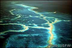
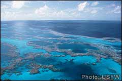
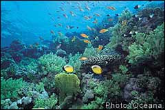
Stretching northwest of Kaua‘i, the Northwestern Hawaiian Islands form the most isolated archipelago in the world. These fragile islands, atolls and shoals contain some of the oldest, healthiest and most extensive coral reefs on the planet and represent 70% of the reefs in U.S. waters. These islands, which encompass tremendous biodiversity, include some of Earth’s oldest living coral colonies. Kure Atoll is the northernmost atoll in the world with living coral colonies well over 1,000 years old and up to 30 feet tall.
People who have researched coral reefs throughout the world agree with Ocean Institute fish ecologist Alan Friedlander’s assessment of the Northwestern Hawaiian Islands: “There’s no place left like it on Earth. The whole system is alive. The ecosystem is thriving and intact.” This vast area sustains a dynamic reef ecosystem, which in turn supports more than 7,000 marine species, with up to half of these species unique to the Hawaiian Archipelago.
 |
 |
|
|
|
|
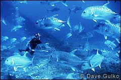
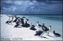
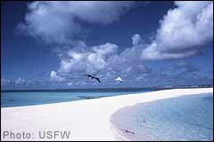
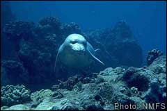
This remote and incredibly diverse ecosystem serves as a Pu‘uhonua (Place of Refuge) to many species of coral, fish, birds, and marine mammals, including the highly endangered Hawaiian monk seal, threatened green sea turtle, and the endangered leatherback and hawksbill sea turtles. An estimated14 million seabirds thrive in these islands, including 99% of the world’s Laysan albatrosses and 98% of the black-footed albatross population. Common thinking among researchers suggests that the Northwestern Hawaiian Islands may be the last predator-dominated ecosystem left on the planet.
The long history of abuse of Northwestern Hawaiian Islands resources includes a massive guano extraction industry, the near annihilation of Hawaiian monk seals by hunters, and whaling ships that ran aground with regularity. Seabird populations sustained severe impacts (for example, from 10 million to 1 million albatrosses on Laysan alone) in order to supply the enormous feather market for hats. This plunder prompted President Theodore Roosevelt in 1909 to set aside the Northwestern Hawaiian Islands as a bird reservation. In the early 1920s black-lipped pearl oysters were wiped out on Pearl and Hermes Atoll to furnish button factories. That species has never recovered.
 |
|
|
|
More recent forms of resource exploitation include the longline fishery overseen by Western Pacific Fishery Management Council (Wespac). In 1999, commercial longliners were prevented access to the Northwestern Hawaiian Islands by court order as a result of repeated “interactions” with the Hawaiian monk seal and threatened and endangered sea turtles, in violation of the Endangered Species Act.
After astonishing and prolonged mismanagement, Wespac was forced to close the severely diminished commercial lobster fishery, as well. After years of effort by the Marine Mammal Commission, Monk Seal Recovery team and environmental community, a lawsuit was filed by Earthjustice, which finally forced the National Marine Fisheries Service (NMFS) to shut down this destructive fishery. The closure was linked to the direct impacts of the lobster fishery on the survival of the monk seal, which is dependant on lobster and several species of by-catch, such as octopus, squid, and eel. (For details on the history of Wespac mismanagement of the lobster fishery, visit www.kahea.org)
Over the past several decades, a range of military activities has left a legacy of toxic pollution on numerous islands, particularly Midway Atoll, Tern Island and Kure Atoll. A full assessment of this problem has not been made. Rusted drums of PCBs (a persistent and potent endocrine disrupter) and other hazardous compounds that are steadily leaking on to the reef may be altering the web of life in ways we do not yet understand, perhaps even contributing to the low survival rates of monk seals.
Presidential Executive Order established the Northwestern Hawaiian Island Coral Reef Ecosystem Reserve in December 2000 after extensive input and support from the public. In fact, this issue has experienced more public participation than any other resource protection issue in recent history.
The NWHI Executive Order represents the strongest level of protection for oceans ever enacted and sets a new standard for comprehensive marine protection. This standard is still being defended as a public process moves forward to determine whether the NWHI Coral Reef Ecosystem Reserve will become a National Marine Sanctuary. The intent of the Executive Order is clear—to preserve and protect the Northwestern Hawaiian Islands in their natural state and to uphold Hawaiian cultural access rights.
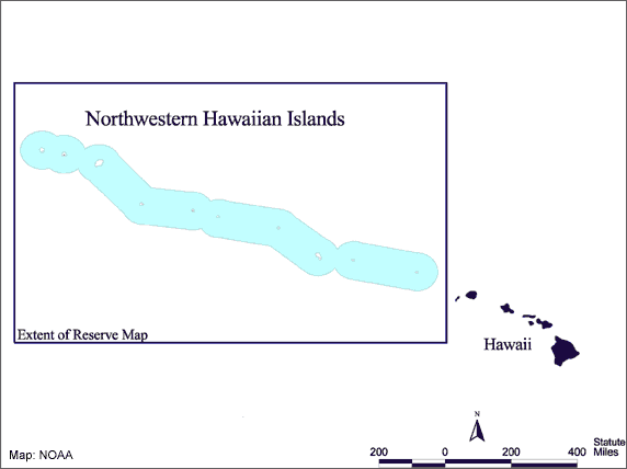
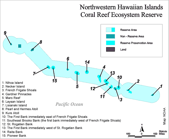
At 84 million acres, the NWHI Reserve is the second largest marine protected area in the world, second only to the Great Barrier Reef. The Reserve extends seaward for 50 miles and surrounds, but does not include Midway or Hawaiian Islands National Wildlife Refuges—established in 1997 and 1909 respectively. The Refuges, under the jurisdiction of the U.S. Fish and Wildlife Service, encompass the islands (except for Kure) and protect waters out to 10 fathoms. The Reserve does not include state waters, which extend from the Refuge boundaries 3 miles seaward. (For additional NWHI maps, visit: http://www.hawaiianatolls.org/maps)
 |
|
Blue defines the approximate Reserve boundaries (click here for more detailed map) |
This ecosystem-based Reserve recognizes Native Hawaiian gathering and fishing rights and grandfathers the existing small commercial and recreational fisheries. The Reserve prevents additional or new types of fishing activities, including coral harvesting. The lobster fishery remains closed under the Executive Order. Fifteen Reserve Preservation Areas totaling 4 million acres are closed to fishing. The vast majority of the closed areas are in shallow waters and therefore, do not impact the bottomfish fishery. The Executive Order stipulates the following:
Specific protections in the Executive Orders include:
The challenge facing advocates for safeguarding the NWHI resources is to ensure that protections established by the Executive Order are preserved in upcoming protection processes. Since the creation of the Reserve, there have been ongoing and relentless efforts by industry and by the Bush Administration to weaken and eliminate these protections.
Wespac has blatantly ignored the Executive Order and continues attempts to expand commercial bottomfishing, re-establish the lobster fishery and develop a commercial coral harvest in the NWHI. For example, Wespac drafted a Coral Reef Ecosystem Fishery Management Plan that called for expanded activities in the NWHI. This move prompted NMFS to exclude Wespac’s plan relating to the NWHI. In addition, the Executive Order was placed under “legal review,” seriously delaying the work of the NWHI Reserve Advisory Council for over a year. However, immense public response helped the Executive Order emerge from the review intact.
 |
|
|
|
The saga for adequate protection continues at the federal and state levels. Two separate public processes are underway that will determine the level of longterm protection for the Northwestern Hawaiian Islands: a Sanctuary designation process, headed by National Oceanic and Atmospheric Administration (NOAA), and a process to establish regulations for state waters led by the Hawai‘i Department of Land and Natural Resources (DLNR).
Pursuant to an amendment to the Magnuson-Stevens Act, a course of action is now underway to determine whether the NWHI Coral Reef Ecosystem Reserve will become a National Marine Sanctuary. Activists have voiced concern about this designation because the Sanctuary Program is based on a “multiple use” approach, not on preservation. Over the years, the Sanctuary Program has demonstrated a limited ability to protect marine resources.
NOAA is developing a Draft Environmental Impact Statement (DEIS) with public scoping meetings held spring 2002 to assess issues of community importance. Even though that was the eighth time the public had been called on to provide comments on protecting the Northwestern Hawaiian Islands, over 1,000 people attended these meetings. In addition, NOAA received well over 11,500 comments supporting strong protections and stressing the need to uphold the Executive Order.
The current challenge is to convince NOAA that the Executive Order serves as the foundation for future protection efforts and that all new protections must—as stipulated in the Order—supplement and complement the current law.
NOAA has stated it will not allow the NWHI Reserve Advisory Council to develop regulations to implement the Executive Order, such as enforcement, permitting, etc. In spite of the fact that the average Sanctuary process is 7 years, NOAA is pushing for the Reserve to become a Sanctuary in less than 2 years. NOAA has agreed to allow the Reserve Advisory Council to revise the NWHI Reserve Operations Plan to better reflect the Executive Order. This plan is currently being prepared by the Reserve Staff and the Reserve Advisory Council and will be sent to Washington, D.C. for final approval. The plan will guide management decisions indefinitely and—if the public agrees—could form the basis for Sanctuary management. It is clear that the public must remain vigilant in order to defend the critical hard-won protections.
 |
|
|
|
The NWHI Reserve boundaries surround, but do not include state waters. These inner state waters comprise the heart of the coral reef ecosystem and hold the majority of biodiversity. The most sensitive ecologically, these waters are also the most vulnerable to human impacts.
DLNR’s proposed regulations for state waters in the NWHI reflect the public’s repeated insistence for strong protection for these fragile waters. The draft regulation would provide protection for sensitive reefs, shallow waters and lagoons, all of which are critical habitat for the highly endangered Hawaiian monk seal and essential habitat for threatened and endangered sea turtles. DLNR is expected to hold public hearings on the draft regulations for state waters in summer 2003.
We can attribute the success of securing the current protections for the NWHI to a sustained high level of public involvement (both local and national), strategically timed assistance from national marine protection organizations and vigilant participation by a small group of committed individuals. Since the beginning of this process in mid-2000, KAHEA has worked closely with a core group of people on all aspects of this issue. Together they advocated rigorous protections, lobbied the Secretary of Commerce and Congress, met with the heads of NMFS, NOAA, White House staff and others on their journey to safeguard the Northwestern Hawaiian Islands’ phenomenal cultural and ecological resources.
 |
|
|
|
Their task now is to continue the vigilant involvement and to broaden public outreach.
KAHEA has generated widespread support, kept the public informed and facilitated public response and involvement in the numerous public participation opportunities. Recently, KAHEA launched an educational campaign to protect the highly endangered Hawaiian monk seal.
Currently, KAHEA is working with state and federal agencies to heighten awareness about the plight of the Hawaiian monk seal. We support efforts of the Marine Mammal Commission in this endeavor and we are invited participants in the current review of the Hawaiian Monk Seal Recovery Plan.
If public support is successful in preserving the protection measures outlined in the Executive Order, the NWHI will reflect the highest level of protection of any Marine Protected Area in the U.S. This Reserve (or Sanctuary) will serve as a model for an ecosystem-based approach to resource management that draws on indigenous knowledge and is supported by the Precautionary Principle. The Northwestern Hawaiian Islands hold tremendous promise for the protection and enhancement of our global marine environment.
|
Mahalo to the following individuals for contributing in a variety of ways to this article: Louis “Buzzy” Agard, Bette Daniels, Beth Flint, Stephanie Fried, Alan Friedlander, Bill Gilmartin, Dave Gulko, Isaac Harp, Marion Anderson Kelly, Colleen Kelly, Lloyd Lowry, Jim Maragos, Shane Pale, Dave Raney, Mark Rauzon, Vicky Holt Takamine, Laura Thompson and Marjorie Ziegler.
http://www.kahea.org/nwhi/index.html
http://www.hawaiireef.noaa.gov/
New: NOAA’s Draft Atlas of the Shallow-Water Benthic Habitats of the NWHI http://biogeo.nos.noaa.gov/projects/pacific/nwhi/data
KAHEA brochure: ‘Ilioholo ika uaua On the Verge of Extinction brochure ( ![]() 215KB)
215KB)
Copyright © 2003 Cha Smith, The Monachus Guardian. All Rights Reserved |